Warren C. Volles
Machu Picchu: A Mighty Example of Incan Civil Engineering and Agricultural Innovation
What I find remarkable about Machu Picchu is how the Incas built the royal estate to blend into the landscape. They adapted to their environment while altering it as little as possible. The Incas had an impressive ability to engineer their structures to withstand tribal threats and the natural challenges of their environment like earthquakes, heavy rainfall, and droughts. From strategically placing Machu Picchu on a mountain ridge to implementing precise ashlar masonry, terraces, drainage systems, and water supply channels, the Incas created a sustainable culture until they were overwhelmed by the Spanish.


Machu Picchu, an enduring symbol of the mighty Incan Empire, is one of the most impressive feats of civil engineering from the ancient world. Constructed in the 15th century CE under the direction of Inca Emperor Pachacuti, this royal estate is strategically positioned high in the Andes Mountains of Peru. It stands on a mountain ridge between Machu Picchu Mountain to the south and Huayna Picchu to the north, at an altitude of about 2,430 meters (7,970 feet) above sea level. This area has significant earthquake activity because it is situated on a geological fault line at the boundary between the South American Plate and the Nazca Plate. The city of Cusco, the former capital of the Inca Empire, is approximately 80 kilometers (50 miles) southeast of Machu Picchu.
Incan Empire
The Incan Empire was one of the most advanced and powerful civilizations in the Americas before the arrival of Europeans. It stretched along the Andes Mountains, covering parts of modern-day Peru, Ecuador, Bolivia, Chile, and Argentina. Much of the empire’s success can be traced back to Emperor Pachacuti, who came to power in the 1400s. He’s known for transforming the small Inca kingdom into a vast and organized empire through military strength, diplomacy, and smart planning. Pachacuti is also credited with designing Machu Picchu, the famous mountain city that continues to be a symbol of Incan innovation and culture.
Geological Fault Line
A geological fault line is a crack or fracture in the Earth’s crust where two blocks of rock have moved past each other. These movements happen because of the constant shifting of tectonic plates, and they can cause earthquakes when pressure builds up and suddenly releases. Fault lines can be found all over the world and are often located near the edges of tectonic plates. Some faults are small and barely noticeable, while others stretch for hundreds of miles. One major fault line lies along the boundary between the South American Plate and the Nazca Plate, where the oceanic plate (Nazca) is slowly being forced underneath the continental plate (South American), creating intense geological activity in the region.
Cusco
At the heart of the Incan Empire was its capital, Cusco, and its incredible network of roads, terraces, and stonework that still impresses people today. Cusco was more than just a capital—it was the center of Incan religion, government, and daily life. Its architecture was built with remarkable precision; massive stones were shaped to fit together so tightly that no mortar was needed, and many of those structures have survived centuries of earthquakes. From Cusco, an extensive system of roads connected distant parts of the empire, making it easier to move armies, supplies, and information. Today, you can still see both Incan and Spanish influences throughout the city, reflecting its long and complex history.
The Incas carefully considered the pros and cons of constructing Machu Picchu on a mountain ridge. The elevated position was a significant advantage because it offered natural protection against potential invaders. In addition, the site's location on an active tectonic boundary meant that the frequent seismic activity fractured the bedrock and provided an abundant supply of granite. This stone was easy to quarry and ideal for building because of its strength and resistance to weathering. However, this same tectonic activity also created significant challenges since the region was prone to earthquakes that could damage their buildings.


The techniques used by the Incas demonstrate their advanced understanding of civil engineering principles and ability to build on a challenging mountain ridge. For example, the structural integrity of Machu Picchu's buildings, which have survived centuries of earthquake activity, shows their mastery of stone masonry and architectural design. Their technique, known as ashlar masonry, where stones are cut to fit together without mortar, provides stability, strength, and earthquake resistance. The Incas used tools such as hard stone hammers for initial roughing out, wooden wedges soaked in water to split stones along precise lines, and bronze and copper chisels for fine shaping. Abrasive sands were also used with water to finish the stone surfaces and ensure a perfect fit. To increase earthquake resilience, the doors and windows have trapezoidal shapes, with a wider base and narrower top. This shape ensures that the weight of the stones above these openings is distributed more evenly to minimize stress concentrations that can lead to structural failure. It also allows the surrounding masonry to interlock more securely, which enhances stability since the structure can flex slightly under stress without collapsing.

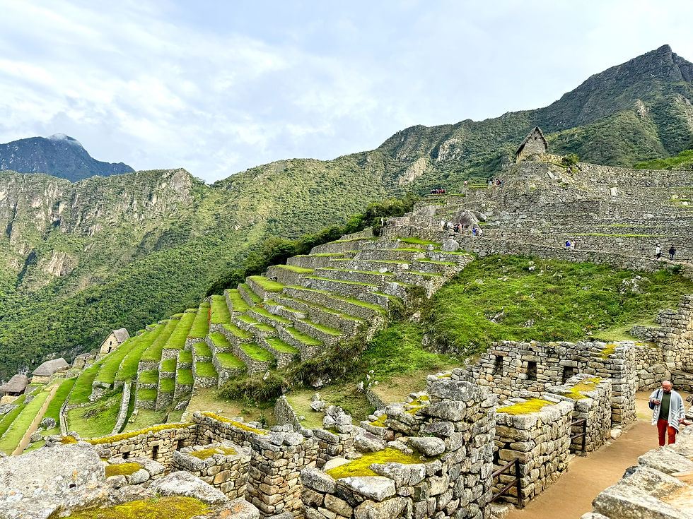
Machu Picchu has numerous terraces that were used for both structural and agricultural purposes. These terraces reduced soil erosion and maximized the land available for farming in this steep mountainous region. They were built with a layering system designed for drainage. Larger stones were placed at the bottom. These stones were topped with gravel, sand, and then fertile soil. This setup prevented the waterlogging of crops during heavy rainfalls that were typical in this region.
The extensive terracing at Machu Picchu indicates that it might have been used as an agricultural laboratory. The Incas experimented with crops at different altitudes to determine the best conditions for their growth. Machu Picchu's varying elevations and microclimates would have made it an ideal place for such experiments.

The Incas built an advanced water management system to ensure an adequate and consistent water supply for Machu Picchu. Water from natural springs on the mountainside was distributed throughout the settlement by a network of stone-built channels and fountains. The precision with which these channels were constructed ensured minimal water loss.

Evidence at Machu Picchu suggests that several structures were intentionally aligned with astronomical events, which is common for Inca architecture that served both practical and ceremonial purposes. The Intihuatana Stone, often called the "hitching post of the sun," is positioned so the Incas could track the sun's movements over the year. It may have served as an astronomical calendar. Similarly, the Temple of the Sun is designed so that the sun marks the winter solstice, while the Sun Gate (Intipunku) is positioned to mark the summer solstice.
The Temple of the Three Windows may represent the three realms of Inca cosmology: Hanan Pacha (the upper world of gods), Kay Pacha (the world of the living), and Uku Pacha (the underworld).


Additional insights
Unfortunately, the Inca abandoned Machu Picchu around 1572 when Spanish conquests expanded throughout the region. The Spanish arrival caused a significant decrease in the Inca population due to diseases for which the Incas had no immunity. The population decline was a major factor in the eventual collapse of Inca society. Machu Picchu remained abandoned until Hiram Bingham, an American historian and explorer, rediscovered it in 1911. Since then, there has been a tremendous amount of interest in the site from researchers and tourists. To ensure its protection and preservation, Machu Picchu was listed as a UNESCO World Heritage Site in 1983 because of its outstanding cultural and historical value.
References
Clark, L. (2000, November 1). The lost Inca Empire. PBS. https://www.pbs.org/wgbh/nova/article/lost-inca-empire/
Cottier, C. (2021, March 18). How the Inca built Machu Picchu. Discover Magazine. https://www.discovermagazine.com/planet-earth/how-the-inca-built-machu-picchu
Frost, P. (2018). Exploring Cusco: The classic guide to Cusco, Machu Picchu and Peru's most famous region (6th rev. ed.)
Gingras, M. (2019). Machu Picchu water management. University of Wisconsin–Madison. https://ancientengrtech.wisc.edu/machu-picchu/machu-picchu-water-management/
Jarus, O. (2023, August 3). Machu Picchu: The Incan estate 8,000 feet high in the Andes. Live Science. https://www.livescience.com/22869-machu-picchu.html
Scher, S. (2015, August 9). Machu Picchu. Smarthistory. https://smarthistory.org/machu-picchu/
The Geological Society of America. (2019, September 19). Machu Picchu: Ancient Incan sanctuary intentionally built on faults. https://www.geosociety.org/GSA/News/pr/2019/19-38.aspx
Wojcik, M., Roppel, R., Tolomeo, B., & Davis, K. (2020, April 22). Machu Picchu – How did they build that? Boise State University. https://www.boisestate.edu/undergraduate-research/2020/04/22/240-machu-picchu-how-did-they-build-that/
Wright, K., Valencia, A., & Lorah, W. (1999). Ancient Machu Picchu drainage engineering. Water History. http://www.waterhistory.org/histories/machupicchu/